

By Scott Hadly
Ventura County Star
Copyright 2007 The E.W. Scripps Co.
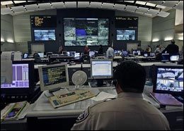 AP Photo/Ric Francis A highway patrol officer monitors the screens at the new traffic center in Calif., which will serve as a hub for emergency response efforts and freeway incident management. |
LOS ANGELES — Looking up at a massive panel of flat-screen televisions with live images and computer maps of highways crisscrossing Los Angeles and Ventura counties, a team of Caltrans traffic engineers and California Highway Patrol dispatchers monitors the vital signs of a region.
In the new $46 million Los Angeles Regional Transportation Management Center, the team of almost two dozen workers is looking for traffic jams, accidents or any anomaly that might slow the flow of the tens of thousands of vehicles coursing the 1,188 miles of freeway that cut through the two counties.
“We’re drawing on multiple sources of data that we feed into the system so that we know at any moment what is going on our freeways,” said Frank Quon, the deputy director of operations for California Department of Transportation District 7, which covers Los Angeles and Ventura counties.
Quon was standing in the cavernous new center Wednesday for its coming-out ceremony.
Engineers get instant notice of problems through state-of-the-art computer modeling, detectors embedded in highways, roadside closed-circuit television cameras and breadbox-sized Doppler radar that flow data wirelessly into the center, Quon said.
Only a small portion of the 101 and 118 highways in Ventura County is now included in the system. But over the next few months, monitors will be placed on all 273 miles of freeway in Ventura County. Those monitors will ultimately feed data into the system, said Steve DeGeorge, director of technology for the Ventura County Transportation Commission, which contracted with the Bay Area company SpeedInfo to do the work.
Ventura County already has two changing message boards — on southbound 101 just north of the 126 interchange, and on the northbound side just after the Santa Clara River Bridge. They inform drivers of detours or traffic delays.
The purpose of all the high tech monitoring is to improve the roadways we have, said Dale Bonner, California’s secretary of Business, Transportation and Housing.
Along with building more highways and improving existing technology, Bonner said Gov. Arnold Schwarzenegger is pushing for better use of what we have.
At the ceremony Wednesday, Bonner looked up at the screen.
“You see all those 18-wheelers,” he said. “We can use this technology to help manage the traffic we have and patch up and expand some of the other modes of transportation that might take some of those trucks off the roadway.”
Whether it’s dispatching Highway Patrol officers to accidents or sending in Caltrans crews to help clear obstacles or simply informing drivers through traffic message signs, the goal is improved efficiency.
Sometimes the urgency of the information is obvious. At 4:30 a.m. Tuesday, a big rig hauling a huge crane crashed on Highway 405, killing the driver and shutting the major artery for Los Angeles.
Doug Failing, the director of Caltrans District 7, said the technology allows for a quicker response as well as more effective rerouting of traffic around the accident scene.
Sometimes the technology simply gives drivers more information about what is going on.
“Getting this information out to the public is very important,” Failing said.
Along with posting the real time traffic data on the Web and sending reports to regional media, Caltrans has also set up changeable message boards giving drivers stuck behind a line of cars basic information on delays or detours, he said.
For retired Caltrans deputy district director Dave Roper, who was part of the team that created the first regional traffic center in 1971, the new control center was mind blowing.
When Caltrans first joined forces with the CHP and the Los Angeles Metropolitan Transportation Authority to try to manage traffic, they used mathematical algorithms, crude monitors embedded in asphalt and a 4-foot high board with a map of the Santa Monica Freeway that was covered with lights.
When the lights were red, they knew there was a problem. That early system of detecting slowing traffic — the sign of bigger problems — formed the basis of the system that is now used, Roper said.
Back then the computers used to process all the information filled a massive room. Now, Roper said, a standard laptop could handle the data.